braga logo
Contact

Connecting Data, Transforming Tomorrow.

In today's volatile, uncertain, complex, and ambiguous (VUCA) environment, effective decision-making is paramount. At Braga Technologies, we bridge the gap of "where" and "how" by harnessing the power of Location Intelligence.
Transform with Us
Powered by Braga

Sustainably Accelerating through Geospatial Tech.

We hear, formulate and implement each solution for you with our advanced geospatial expertise. Our solutions are carefully designed to help you today, tomorrow and for many years to come.

Big Data Processing
Powerful

Technologies that integrate, process, analyze, and visualize big data for your collective’s solution.

IoT and AI Integration
Dynamic

Connect to IoT and AI tools, models, or hardwares for furhterly advanced and integrated problem solving.

Rich Analytics
Advanced

Advanced tools that Braga provides helps to come up with analytics that beneficial to tackle various challanges.

Data Services
Global

Not bounded by space and time, we help in multiple platforms, adapting to different conditions and terrains.

geodashboard screenshot
From Seeing Where to Understand Why.

Analyze site conditions, measure key urban indicators, and perform spatial analysis — directly in the browser.
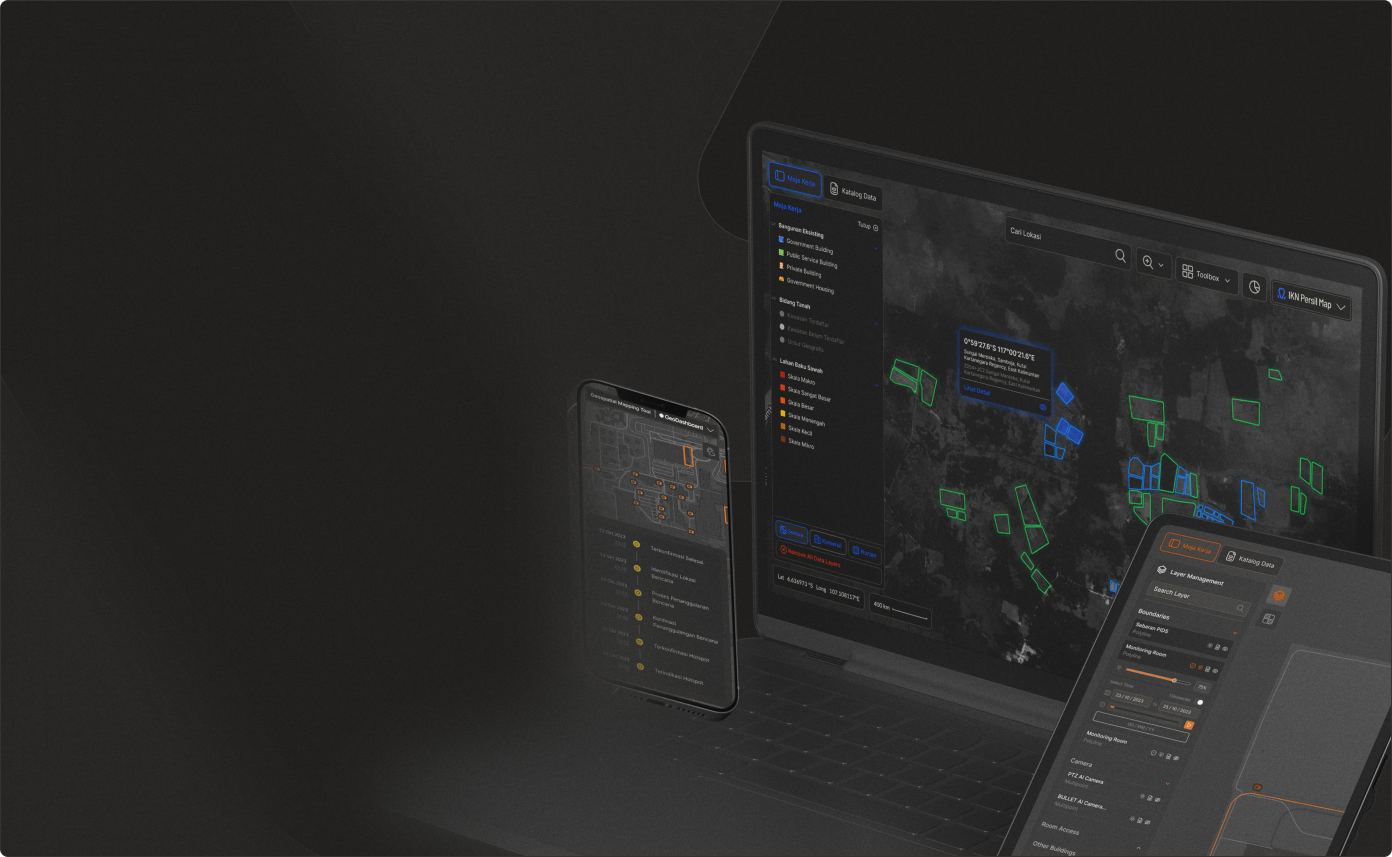
Go to GeoDashboard
Spatial Range Calculation

Visualize multiple layers both vector and raster to perform a detailed, precise, and insightful analysis.

Multi-Format Data Visualization

Easily visualize data in point, polygon and polyline format. Inspect rich data display for each attribute.

Bootstrap Approach

Created in no time through bootstrap. Get all the desired features, tailored to your needs.

logbook screenshot
Log Your Journey, Endless Possibility

Stay tuned for the unveiling of our meticulously crafted logbook – where every entry marks a step toward unparalleled organization and memorable experiences. Launching soon!

Go to LogBook
Simplify storytelling

Streamline your storytelling process with our intuitive tools, enabling you to convey your message effectively.

Craft maps that reflect your style and identity

Express your individuality through meticulously crafted maps tailored to your personal style and identity.

Expertise

Entrusted by The Expert, Enterprise, and Government.

We have mapped and navigated in multiple parts of the globe across various fields and industries as a testament of how universal geospatial technology is.

Retail and Real Estate

Oil, Mining, and Gas

Logistics and Fleet

Agriculture

01/

"Kolaborasi kami dengan PT Braga Teknologi Nusantara dalam pengembangan web geoportal Bhumi. Aplikasi geoportal Bhumi telah memberikan manfaat kepada stakeholder internal dan eksternal , dengan Geoportal Bhumi dapat melihat lokasi bidang tanahnya dan memperoleh informasi umum terkait letak tanah, jenis hak, dan luasnya. Terima kasih kepada tim Braga atas bantuan teknisnya yang telah secara signifikan meningkatkan layanan kami kepada publik."

Kementerian ATR BPN
Analis Sistem Informasi dan Jaringan - Sub Bidang Pengembangan Sistem Informasi

Kementerian ATR BPN

02/

"Working with Braga Technologies has been an outstanding experience. They have an exceptional ability to quickly grasp our needs and turn them into effective, well-executed solutions. Their intuitive and user-friendly UI/UX design, combined with strong technical expertise in mapping, enabled us to establish our GIS platform in a remarkably short time. This platform has significantly improved our data visualization capabilities and strengthened data-driven decision-making. Braga Technologies has proven to be a reliable, responsive, and forward-thinking partner, always ready to provide valuable insights and support whenever needed."

Naufal Ian Badan Gizi Nasional
Naufal Ian - Data Team Pusdatin

Badan Gizi Nasional

Our Work

Braga Solutions, Integrated to You.

Our interdisciplinary design and development approach accelerates the geospatial tech delivery to your hands.

City Information Modelling (CIM)

The Ministry of Public Works (PUPR)

Read More
Geospatial Dashboard for National Land Governance

Ministry of Agrarian Affairs and Spatial Planning / National Land Agency - ATR/BPN

Read More
Single Source of Truth Dashboard for Enterprise Geospatial Data

PT. Borneo Indobara

Read More
Real-time Geotechnical Monitoring and Risk Management System

PT. Borneo Indobara

Read More
Early Warning System for Lahar and Flood Monitoring

National Agency for Disaster Management - BNPB

Read More
Digital Land Information & Certificate Verification System (BHUMI)

Ministry of Agrarian Affairs and Spatial Planning / National Land Agency - ATR/BPN

Read More
Multi-Hazard Early Warning System

National Agency for Disaster Countermeasure - BNPB

Read More
Get started today

Find out how you can maximize the value from data and strengthen your decision making

Product

Geodashboard

Logbook

Poin

Service

Data Service

Software Development

Company

About

Culture

Career

Contact us

Indonesia’s Leading Geospatial Technology that optimize analytics and performance, moving the world one map at a time.

LinkedIn Youtube

© Braga Technologies 2024

Back to top ↑

Information Security Policy

Terms and Condition